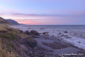
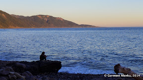
The northern section of the Lost Coast Trail is a fantastic 3-day, 25-mile route. It goes all along the Pacific Ocean via rocky beaches, sandy beaches, bluff trails and creek crossings. Five of us walked along this route during Memorial Day weekend in 2014 (May 24, 25, 26).
This article explains how we prepared for our trip. A fair amount of planning was necessary. First, Lost Coast Trail is a point to point hike, so we needed a shuttle service. Second, some sections are not navigable in high tide conditions. So tide tables were important. Finally, we needed bear canisters, water purifiers (not just water filters) and readiness for wind, rain and fog.
- Hiking & Backpacking in King Range National Conservation Area — must read!
- An article by the ranger for King Range for hiking on Memorial Day weekend. Good reading for backpacking etiquette.
Maps: An excellent map is BLM Official Trail Map (free, online). A large sized printed copy is available for $5 at Petrolia General Store: 40 Sherman Ave, Petrolia, CA 95558. For store hours, call (707) 629 3455. On Day 1, we stopped at this store on our way to Mattole River trailhead. The map is also available by mail: see this page for information. Another map is BLM Road Map, which shows locations of towns and trailheads.
Trailhead Locations: As per local wisdom, strong winds occasionally blow from north to south. So almost everybody hikes from north to south so that we do not face these winds directly.
(North) Mattole River trailhead lies at the intersection of Lighthouse Rd & Prosper Ridge Rd, Petrolia, CA 95558.
(South) Black Sands Beach trailhead lies at the intersection of Beach Rd & Ridge Rd, Whitethorn, CA 95589.
Hotel Location: Driving north from San Francisco / Mountain View / San Jose, the town that is close to both trailheads is Garberville, CA. It is off Highway 101. Driving distance from Mountain View, CA was 4 hrs, 15 mins; 238 miles.
Hotels in Garberville did not show up on Expedia, Hotwire and Kayak. They did show up on booking.com: Motel Garberville and Humboldt Redwods Inn. We stayed in Motel Garberville. It was decent: quiet, clean bathrooms and clean beds.

Lost Coast Trail is a point to point hike. So a car shuttle is necessary. Driving time between the two trailheads is two hours one-way. The following companies provide shuttle service for people (one of them provides shuttle service for cars):
- Lost Coast Adventures: Contact Blu Graham at lostcoastadventuretours@gmail.com or call him at (707) 986 9895 or (707) 502 7514. See Yelp reviews.
- Lost Coast Shuttle: Contact Sherri Luallin at sherriluallin@gmail.com or call her at (707) 986 7437 or (707) 223 1547. Yelp Reviews. Interestingly, Sherry will also shuttle a car instead of people. We availed of this option.
- Lost Coast Trail Transport: Contact : Roxanne Beijan at roxanne@saber.net or call her at (707) 986 9909. See Yelp reviews. When we contacted Roxanne, we learnt that she no longer provides shuttle service for the northern section of the Lost Coast Trail. She does provide shuttle service for the southern section.
- As per this page, Andrew Parmenter of Hey Taxi! can provide shuttle service even though he does not have an official permit. Contact Andrew at andrew@norcaltaxi.com or call him at (707) 391 8672. We did not contact him.
Most people from bay area (San Francisco / Mountain View / San Jose) drive their cars to the Black Sands Beach trailhead (the southern end point of Lost Coast Trail). Then they hop onto a shuttle, leaving their cars behind. The shuttle takes them to Mattole River trailhead (the northern end point of Lost Coast Trail). They hike for 3 days to reach Black Sands Beach trailhead, pick up their cars and drive back home.
We made our trip plans about one week before Memorial Day weekend. By that time, all shuttles for May 24 had been booked. However, Sherri Luallin of Lost Coast Shuttle agreed to ship our car from Mattole River trailhead to Black Sands Beach trailhead for $250. So we drove directly to Mattole River trailhead, waited for Sherri to show up and handed her one key to our car. We kept the other key with ourselves. On the second day, while we were hiking, Sherri shipped our car. By the time our hike got over, our car was waiting at Black Sands Beach trailhead.

Two articles have plenty of details: (a) Arturo Crespo's page has text and hand-drawn maps copied from from this book, and (b) ClimbWild.Net article. We carried printouts of both articles with us. But we did not refer to either of them during our hike. The following pieces of information were sufficient:
- BLM Official Trail Map, which we picked up from the General Store in Petrolia.
- Campsite locations: we could pitch our tents near every major creek. This includes Cooskie Creek, Randall Creek, Spanish Creek, Kinsey Creek, Big Creek, Big Flat Creek, Shipman Creek and Buck Creek.
- Some sections of Lost Coast Trail are impassable at high tide. These are clearly marked in the BLM Official Trail Map.
- Tide tables (see below). We made sure that we negotiated impassable sections in the BLM Official Trail Map during "outgoing tides" (when water level is receding from high tide to low tide).
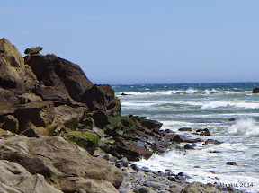
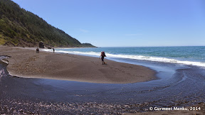
- About half a mile south of Sea Lion Gulch (at about 4.7 mile mark), there is a distinctive rock formation that cannot be crossed along the ocean, no matter how low the tide; we have to follow a bluff trail instead. See the image at the bottom of this page. There is a creek just before this rock formation. Follow the creek inland, looking for a trail that runs parallel to the coastline. Photo of the rock.
- We were always on the lookout for bluff trails or inland trails. It is easier to talk along such trails instead of rocky and sandy beaches.
- Water availability: Along Lost Coast Trail, there are several major creeks like Cooskie Creek and Randall Creek, about two to three miles apart. In between major creeks, there are several smaller, unnamed creeks shown on BLM Official Trail Map. All creeks, big or small, had plenty of water on Memorial Day weekend. Depending upon how much water you consume on sunny days and how often you wish to stop at streams to filter water, you may decide how much water to carry.
Day 0 (Friday)
We drove from Mountain View to Motel Garberville at 948 Redwood Drive, Garberville, CA 95542 (4 hrs, 15 mins in light traffic, 238 miles).
On our way to Garberville, we had our dinner at Shree Indian Restaurant in Petaluma (Google Maps Location). We liked the food and service so much that on Day 3, we stopped here again for dinner, on our way back to Mountain View.
Day 1 (Saturday)
From our hotel in Garberville, we drove to Petrolia General Store at 40 Sherman Ave, Petrolia, CA 95558 (2 hours; 62 miles). Most of this route is along mountainous, windy roads. At Petrolia General Store, we picked up a large sized "BLM Trail Map" for $5, along with last minute purchases. There was no cell phone reception here. We used a pay phone to contact Lost Coast Shuttle to figure out what time we would be meeting Sherri at the Mattole River trailhead.
From Petrolia General Store, we drove to Mattole River trailhead at the intersection of Lighthouse Rd & Prosper Ridge Rd, Petrolia, CA 95558 (15 mins; 5 miles).
We walked 8.3 miles from Mattole River campground to Randall Creek campground.
Day 2 (Sunday)
We walked 9.7 miles from Randall Creek campground to Shipman Creek campground.
While we were on the trail, Sherri Luallin from Lost Coast Shuttle shipped our car from Mattole River trailhead to Black Sands Beach trailhead.
Day 3 (Monday)
We walked 6.6 miles from Shipman Creek campground to Black Sands Beach trailhead at intersection of Beach Rd & Ridge Rd, Whitethorn, CA 95589. We then drove back to Mountain View (5 hours; 262 miles). We made sure that we walked the least on Day 3, so that we could start driving back by 2pm.
We had our dinner at Shree Indian Restaurant in Petaluma (Google Maps Location).
See Weather Forecast for Shelter Cove, CA. Click on 'Customize' → 'Humidity'. Also click on 'Customize' → 'Feels like' to get graphs like this:
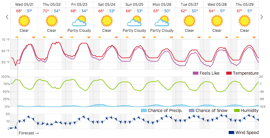
Rain: Chances of rain were 10% at night. So we decided to take tent flies (canopies) with us.
Wind: Lost Coast is known to have strong, intermittent winds that blow from north to south. So each one of us carried a hooded rain & wind jacket.
Humidity: high (50% to 90%). Several trip reports mentioned that by morning, dew makes everything wet. Backpacks are generally waterproof. Still, you may consider lining it with a large plastic bag. I packed various items in smaller sized ZipLock bags.
Temperature: 8C to 10C at night. Our sleeping bags could handle this temperature comfortably. We did not need thermals at night (Memorial Day weekend — May 2014). Three layers sufficed for me: a synthetic t-shirt, a sweat shirt and a rain jacket. Plus convertible pants.
Several websites provide tide tables for Shelter Cove, CA: American Tides — Tides And Currents — Mobile Geographics.

I like Mobile Geographics because "outgoing tides" (when the tide is changing from 'high tide' to 'low tide') are marked in green. These are the times when we should be crossing areas marked 'impassable at high tide' in the BLM Official Trail Map.

Purifier vs Filter: For the Lost Coast Trail, we need a water purifier, not merely a water filter. The differences between the two are explained in two excellent articles by REI: here and here. By the time water makes its way to the ocean, water may have been polluted by human waste and animals. So it is important to remove tiny viruses, not just large sized bacteria. Virus removal requires chemical treatment.
A water purification system can be built in two ways:
- A water filter like Katadyn Hiker Pro ($60, 11oz). Plus MSR Sweet Water Purifier Solution.
- A water purifier like First Need XLE Elite Purifier ($99, 16oz). No need for further chemical treatment with tablets or drops.
We used the second option. One purifier sufficed for our group of five.
Water availability: Along Lost Coast Trail, there are several major creeks like Cooskie Creek and Randall Creek, about two to three miles apart. In between major creeks, there are several smaller, unnamed creeks shown on BLM Official Trail Map. All creeks, big or small, had plenty of water on Memorial Day weekend. Depending upon how much water you consume on sunny days and how often you wish to stop at streams to filter water, you may decide how much water to carry.

Bear canisters are required for hiking along Lost Coast Trail. Heavy fines are levied if a ranger catches you without one. See Hiking & Backpacking in King Range National Conservation Area.