
Marin Headlands is a large park north of Golden Gate Bridge in San Francisco. It has excellent hikes through hills and beaches, with great coastal views and wildflower displays in spring. There are multiple trailheads and several miles of hiking trails, so you can make long interesting loops. Some examples are described below.
Best Months to Visit: Spring and summers are best. Avoid foggy days. In winters, it is likely to be cold and windy.
Accommodation: You can camp at various campsites or stay overnight at the Marin Headlands Hostel.
Geology: Marin Headlands — nice description by Ted Konigsmark at GeologicTrips.
List of Hikes
|
1.6 miles
300 ft |
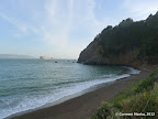
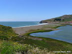
Black Sands Beach |
|
4.0 miles
200 ft |
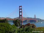
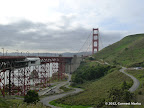
Golden Gate Bridge |

|
3.8 miles
900 ft |
Kirby Cove |
|
13.1 miles
2300 ft |
Muir Beach to Tennessee Beach - Long Loop |
|
10.8 miles
1700 ft |
Redwood Creek - Miwok - Coastal Trail |
|
2.0 miles
250 ft |
Rodeo Beach |
|
9.4 miles
2300 ft |
Tennessee Cove - Long Route |

|
11.5 miles
2600 ft |
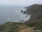
Coastal Trail in Marin Headlands |
|
7.4 miles
1800 ft |
Golden Gate Bridge to Black Sands Beach |

|
7.6 miles
1000 ft |
Miwok Trail - Rodeo Beach - Point Bonita |

|
10.3 miles
1800 ft |
Redwood Creek - Dipsea - Homestead Valley - Dias Ridge |
|
31.4 miles
4000 ft |
Ridge to Bridge - 2011 |

|
9.5 miles
1500 ft |
Rodeo Beach - Black Sands Beach Loop |

© Copyright 2008—2023, Gurmeet Manku.