
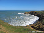
Mori Point is a promontory jutting out into the ocean between Sharp Park Beach and Rockaway Beach. It offers awesome views of the jagged coastline and the Pacific. A 9-mile hike from the northern end of Sharp Park Beach to southern end of Pacifica State Beach is among the best in the bay area.
Best Months to Visit: Any time of the year. Winters may be cold and windy.
List of Hikes
|
6.1 miles
700 ft |
Sharp Park Beach to Rockaway State Beach |
|
8.2 miles
900 ft |
Sharp Park Beach to Pacifica State Beach |

|
9.0 miles
1500 ft |
Fassler Ave - Sweeney Ridge - Mori Point - Pacifica Beach |

|
11.8 miles
2300 ft |
Sneath Lane to Mori Point |

© Copyright 2008—2023, Gurmeet Manku.