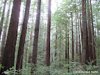
Best time to visit: I love to visit redwoods in winters, especially after rains, when creeks flow with water and vegetation looks fresh and green. Generally speaking, trails are walkable even after rains because layers of leaves form a carpet that protects our feet from mud. Redwoods are popular during summers as well because they are cooler than open spaces, providing respite from the sun.
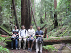
Notes: In Feb 2010, the Visitors Center was closed, no maps were available and the restrooms were also closed due to shortage of funds. So we took maps with ourselves to explore this beautiful park.
There are many trails near Park HQ. In fact, there are too many intersections!
|
8.1 miles
1800 ft |
Coyote Ridge — Iverson Loop |

|
6.2 miles
1500 ft |
Coyote Ridge — Slate Creek — Summit — Old Tree |

|
8.8 miles
2000 ft |
Shaded Loop Around Portola Redwoods |

Slate Creek Trail is a gorgeous trail heading east toward Long Ridge Open Space Preserve. Depending upon how long we walk along this trail, we get hikes of different lengths.
|
5.8 miles
700 ft |
Slate Creek Trail — Short Route |

|
7.3 miles
900 ft |
Slate Creek Trail — Medium Route |
|
9.8 miles
1500 ft |
Slate Creek Trail — Long Route |

Peters Creek Loop Trail lies in a relatively remote section of the park. It is a worthy destination that ends in a one-mile loop that crosses the creek twice. In Feb 2010, there are no bridges at either crossing. So we had to wade through the creek.
|
11.5 miles
1800 ft |
Peters Creek Loop |

|
16.0 miles
2800 ft |
Peters Creek Loop — Extended Route |

Tarwater Loop Trail lies in Pescadero Creek County Park, which lies to the west of Portola Redwoods. Routes going through Tarwater Loop Trail may start either at Tarwater Trailhead (free parking) or at Park HQ (paid parking).
|
7.2 miles
900 ft |
Tarwater Loop from Portola Redwoods |
Butano Ridge lies to the south east of Portola Redwoods, inside Pescadero Creek County Park. The ridge is accessible by trails starting at Park HQ.
|
12.8 miles
2100 ft |
Butano Ridge Loop |

Long Ridge Open Space Preserve lies to the east of Portola Redwoods. Hikes from Long Ridge are pretty long, dropping down from Highway 35 (Skyline Blvd) to Slate Creek.
|
15.5 miles
3000 ft |
Peter's Creek Loop from Skyline Blvd |