
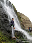
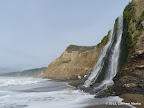
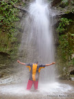
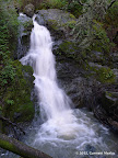
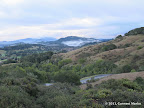
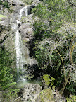
Alamere Falls in Point Reyes is one of the two waterfalls in CA that pour directly into the Pacific Ocean. The waterfall is 40 ft tall. The final descent to the beach requires a scramble. In 2012, there was a rope to make the descent safer. During low tide, one may walk half a mile to the south of the beach and several miles to the north to reach Wildcat Camp. The beach walk adds character to the hike.
Close to the junction of Alamere Falls Trail and Coastal Trail, there is an unmarked junction with a trail that goes to Stormy Stack. This side trip is about one mile round trip. The views from Stormy Stack are pretty awesome. This trail is not shown on the official Point Reyes map. It is shown on trail maps sold by Tom Harrison.
|
9.5 miles
1000 ft |
Alamere Falls from Palomarin Trailhead |
|
15.8 miles
2800 ft |
Alamere Falls from Five Brooks Trailhead |
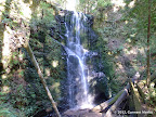
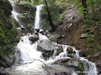
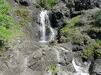
The hike to Berry Creek Falls in Big Basin Redwoods is one of the classic hikes in the bay area. After rains, creeks are flowing and the falls are pretty impressive. At 70 ft, Berry Creek is the tallest waterfall in the bay area. The standard route is not listed below. Instead, two other routes are:
|
9.0 miles
1600 ft |
Berry Creek Falls - Route II |
|
15.6 miles
2300 ft |
Berry Creek Falls - McAbee Overlook from Waddell Beach |
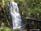
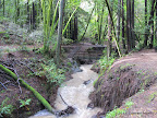
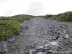
Maple Falls is a beautiful waterfall inside Forest of Nisene Marks, a redwood forest in Santa Cruz. The last half mile to Maple Falls, beyond Bridge Creek Historic Site, is all along a creek. The trail switches from one side of the creek to the other almost a dozen times. After heavy rains, we have to wade in about 6 to 12 inches of water at some of these crossings. A few spots require scrambling, adding to overall fun!
|
8.6 miles
800 ft |
Maple Falls - Route I |
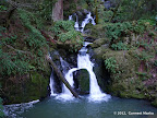
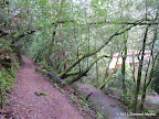
The hike to Cataract Falls in Marin County is all along a trail that meanders next to a creek which overflows with water after rains. No other waterfall hike goes next to a creek for so many miles. Cataract Falls Trail is relatively steep. However, the sound of flowing water, wet vegetation and shaded trails makes for an awesome overall experience. By June, water levels recede substantially. The hike is still pleasant since trails are shaded, providing respite from the sun.
|
3.1 miles
1000 ft |
Cataract Falls - Route I |
|
5.8 miles
1400 ft |
Cataract Falls - Route II |
Uvas Canyon is a hidden gem in the bay area. It is a gorgeous park in Morgan Hill with cascades of water in two creeks amid thick forest. The best time to visit is February and March, soon after rains. The waterfalls are small sized but quite a spectacle. Trails are shaded throughout and meander next to creeks for several miles.
|
5.6 miles
1600 ft |
All Waterfalls in Uvas Canyon |

|
2.8 miles
900 ft |
Swanson Creek - Uvas Creek |

Ribbon Falls is one of the 'secret' waterfalls in Point Reyes that is rarely visited.
|
4.5 miles
100 ft |
Unknown Coast in Point Reyes |
McWay Falls is one of the two falls in California that fall directly into the ocean. Situated in gorgeous Big Sur, the falls are a popular tourist attraction. The falls are visible from a distance from a short flat trail high up in the cliffs to the north of McWay Falls. It is illegal and dangerous to scramble down to the bottom of the falls. The hike itself is not particularly challenging. The views of the falls are pretty good.
|
1.2 miles
150 ft |
McWay Falls |

Dawn Falls in Baltimore Canyon Open Space Preserve is reachable by a short, pleasant hike that meanders next to a creek for about one mile. The hike may be extended by trips to nearby Blithedale Summit Open Space Preserve and King Canyon Open Space Preserve.
|
2.2 miles
200 ft |
Dawn Falls |
|
4.2 miles
700 ft |
Dawn Falls — Piedmont Trail |
|
5.8 miles
900 ft |
Dawn Falls and King Mountain Loop |
|
7.3 miles
1000 ft |
Dawn Falls — Piedmont Trail — King Mountain Loop |
|
11.9 miles
2200 ft |
Grand Loop through Baltimore Canyon, King Mountain & Blithedale Summit |

Cascade Falls is a small waterfall in Marin County reachable by a short hike. Not as spectacular as other waterfalls listed in this article. However, the overall experience in overcast conditions, soon after rains, is quite pleasant. The hike to Cascade Falls may be combined with other destinations like Pine Mountain for longer hikes in the area.
Parking near the trailhead is a major challenge. You may have to park your car up to half a mile away and walk along the road to reach the trail head.
|
1.6 miles
200 ft |
Cascade Falls - Route I |
|
2.9 miles
500 ft |
Cascade Falls - Route II |
|
8.0 miles
1800 ft |
Cascade Falls - Pine Mountain |
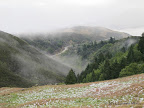
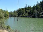
Carson Falls is a series of small waterfalls in Marin County that is best visited soon after heavy rains. Neither the waterfall nor the trails leading to the waterfall are as spectacular as others listed in this article. However, soon after rains, in overcast conditions, the hike is pretty awesome. Two points of interest close to the waterfalls are Pine Mountain and Kent Lake. The views from Pine Mountain stretch for several miles and are pretty awesome. Kent Lake is a large serene lake. Visiting either or both of these destinations makes the hike to Carson Falls more interesting.
|
3.6 miles
900 ft |
Carson Falls - Route I |

|
2.3 miles
900 ft |
Carson Falls - Route II |
|
8.0 miles
1600 ft |
Carson Falls - Route III |
|
6.2 miles
1500 ft |
Carson Falls - Pine Mountain - Route I |
|
5.6 miles
1400 ft |
Carson Falls - Pine Mountain - Route II |
|
6.7 miles
1500 ft |
Carson Falls - Kent Lake - Route I |
|
5.5 miles
1500 ft |
Carson Falls - Kent Lake - Route II |
|
9.1 miles
1700 ft |
Carson Falls - Kent Lake - Pine Mountain - Route I |
|
8.4 miles
2100 ft |
Carson Falls - Kent Lake - Pine Mountain - Route II |
