
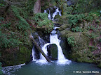
The hike to Cataract Falls in Marin County is all along a trail that meanders next to a creek which overflows with water after rains. No other waterfall hike goes next to a creek for so many miles. Cataract Falls Trail is relatively steep. However, the sound of flowing water, wet vegetation and shaded trails makes for an awesome overall experience. By June, water levels recede substantially. The hike is still pleasant since trails are shaded, providing respite from the sun.
|
3.1 miles
1000 ft |
Cataract Falls - Route I |
|
5.8 miles
1400 ft |
Cataract Falls - Route II |
Uvas Canyon is a hidden gem in the bay area. It is a gorgeous park in Morgan Hill with cascades of water in two creeks amid thick forest. The best time to visit is February and March, soon after rains. The waterfalls are small sized but quite a spectacle. Trails are shaded throughout and meander next to creeks for several miles.
|
5.6 miles
1600 ft |
All Waterfalls in Uvas Canyon |

|
2.8 miles
900 ft |
Swanson Creek - Uvas Creek |

Henry Cowell Redwoods State Park is in two sections. The northern section is called Fall Creek Unit. It is less developed and gives a feeling of wilderness. The southern section is much more developed, with picnic areas and many more visitors. Fall Creek Trail goes for 2.5 miles all along Fall Creek. The trail keeps to the edge of the creek at all times. From winter through spring, there is plenty of water in the creek, making this one of the best hikes in the bay area.
|
7.0 miles
1500 ft |
Truck Trail - Fall Creek Trail - Route I |
|
8.2 miles
1800 ft |
Big Ben Tree and Fall Creek |

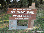
Steep Ravine Trail in Mount Tamalpais is a gorgeous trail that is all along Webb Creek for about 1.5 miles. Routes going through Steep Ravine Trail are pretty awesome when the creek is full of water after rains.
|
6.5 miles
1500 ft |
Steep Ravine - Matt Davis |

|
8.5 miles
2100 ft |
Matt Davis - Coastal - Willow Camp - Steep Ravine |

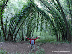
Forest of Nisene Marks is a beautiful redwood forest with trails going along trails: Bridge Creek Trail and Aptos Creek Trail. Since 2007, Aptos Creek Trail has been closed because a landslide destroyed a section of the trail. However, several web articles suggest that some volunteers have installed ropes along this trail, so those looking for adventure may try visiting Aptos Creek Trail.
|
8.6 miles
800 ft |
Maple Falls - Route I |
|
9.5 miles
1500 ft |
Hoffman Historic Site - Route II |

Redwood Regional Park is in a surprising location: Oakland. Stream Trail is a three mile long trail that goes all along Redwood Creek. Parallel to Stream Trail are three other trails: East Ridge Trail, Fern Trail and West Ridge Trail. The two ridge trails are fire roads high up along ridges, allowing cyclists. Many sections of these trails are in the open, so avoid them in summers. In constrast, Fern Trail goes through a shaded forest full of redwoods. There are several other trails connecting these four trails with each other. So one may form many different loops. For a loop that includes walking along a creek and going through cool redwood forests, combine Stream Trail and Fern Trail with other trails that connects these two trails.
|
7.0 miles
1100 ft |
Stream Trail - French Trail |

Joaquin Miller Park is a surprisingly beautiful park right in the middle of Oakland. Palos Colorados Trail is a gorgeous trail that meanders next to Palo Seco Creek. There are other trails next to creeks in Joaquin Miller. Interesting loops may be formed by combining these trails together. Palos Colorados Trail remains cool and shaded even in summers.
|
5.4 miles
1100 ft |
Long Loop in Joaquin Miller Park |
|
9.3 miles
1500 ft |
Joaquin Miller and Dimond Canyon Loop |
In Butano State Park, Butano Creek Trail and Six Bridges Trail go all along Little Butano Creek for a total of about two miles. Best visited in winters and early spring, after heavy rains.
|
8.2 miles
1900 ft |
Little Butano Creek - Ano Nuevo - Candleabra - Route II |
Purisima Creek Trail goes along Purisima Creek for about 2.3 miles. In the east, it leaves the creek but continues for 1.6 miles to reach the eastern trailhead. Purisima Creek Trail divides the park into two sections: north and south. A hike along this trail may be combined with trails in the north or with trails in the south for awesome loops.
|
9.9 miles
1800 ft |
Purisima Creek - North Entrance - Route II |
Soberanes Canyon Trail in Garrapata State Park goes through a redwood forest, meandering next to Soberanes Creek for about 1.5 miles. Loops involving Soberanes Canyon Trail are pretty awesome, especially when the creek is full of water.
|
6.2 miles
2200 ft |
Doud Peak |

|
4.8 miles
1700 ft |
Soberanes Canyon - Rocky Ridge |

Land of Medicine Buddha is a quiet serene Buddhist monastery in Santa Cruz. A six-mile loop trail goes along a creek for the first two miles. Overall, the hike is shaded throughout. The section that goes next to the creek is the most gorgeous.
|
6.2 miles
900 ft |
Loop Around Land of Medicine Buddha |
Los Trancos Trail in Foothills Park is really gorgeous after rains. It goes over 21 wooden bridges at various locations. These are marked as LT1, LT2, LT3 and so on in the trail map. For about a mile, between LT11 and LT13, the trail meanders next to Los Trancos Creek. This is the most beautiful section of the trail.
|
7.6 miles
1400 ft |
Los Trancos Trail - Regular Loop |

|
11.4 miles
2000 ft |
Los Trancos Trail - Long Loop |

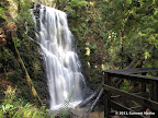
Several trails in Big Basin are along creeks. Among the prominent ones are Skyline to the Sea Trail that goes along different creeks for several miles, Berry Creek Falls Trail, Timms Creek Trail and Shadowbrook Trail.
|
15.6 miles
2300 ft |
Berry Creek Falls - McAbee Overlook from Waddell Beach |
Creek Trail and Ewing Hill Trail go along Adobe Creek for a combined distance of almost one mile. These trails are shaded by tall trees and quite scenic. The intersection of Creek Trail with Toyon Trail and Long Bunny Loop is near the intersection of three different creeks called Adobe Creek, Middle Fork and West Fork. The ambience near this intersection is particularly peaceful. There are picnic tables at this point.
|
3.9 miles
1200 ft |
Medium Loop in Hidden Villa - Route I |
|
8.3 miles
2000 ft |
Long Loop in Hidden Villa from Rhus Ridge |

In Portola Redwoods, many trails cross creeks or meander for short sections next to creeks. The hike to Peters Creek Loop is next to a creek for quite a long section.
|
11.5 miles
1800 ft |
Peters Creek Loop |

Phleger Estate is a hidden gem in the bay area with beautiful redwood trails. Raymundo Trail and Miramontes Trail are along West Union Creek for a combined distance of over a mile.
|
6.7 miles
1400 ft |
Phleger Estate from Skyline Blvd - Route I |

|
6.2 miles
800 ft |
Phleger Estate from Zwierlein Picnic Area - Route I |
