
An awesome, long hike through varied terrain. The route includes panoramic views from fire roads and ridge trails, fully shaded trails leading to waterfalls and cascades, creek crossings without bridges.
Location: Big Basin Redwoods State Park
 Large-sized Google Map
Location: along Whitehouse Canyon Road, Pescadero, CA 94060 . No street address. Parking area is not visible in Google Maps.
Directions: On Highway 1, about 0.1 miles south of Rossi Rd, there is an unsigned dirt road. This road is called Whitehouse Canyon Rd in maps but there is no sign on the road itself except a logo of Skylark Ranch (white with a green triangle). Drive 2.3 miles east along this dirt road to reach a pullout for about 8 to 10 cars. At this point, you shall see a sign that says "No Further Public Access Past This Point". The trailhead is close to this sign, on your right.
Google Maps:
Parking Fees: None (last visited: May 2010)
Capacity: 8 to 10 cars
Latitude: 37.169721 Longitude: -122.315855
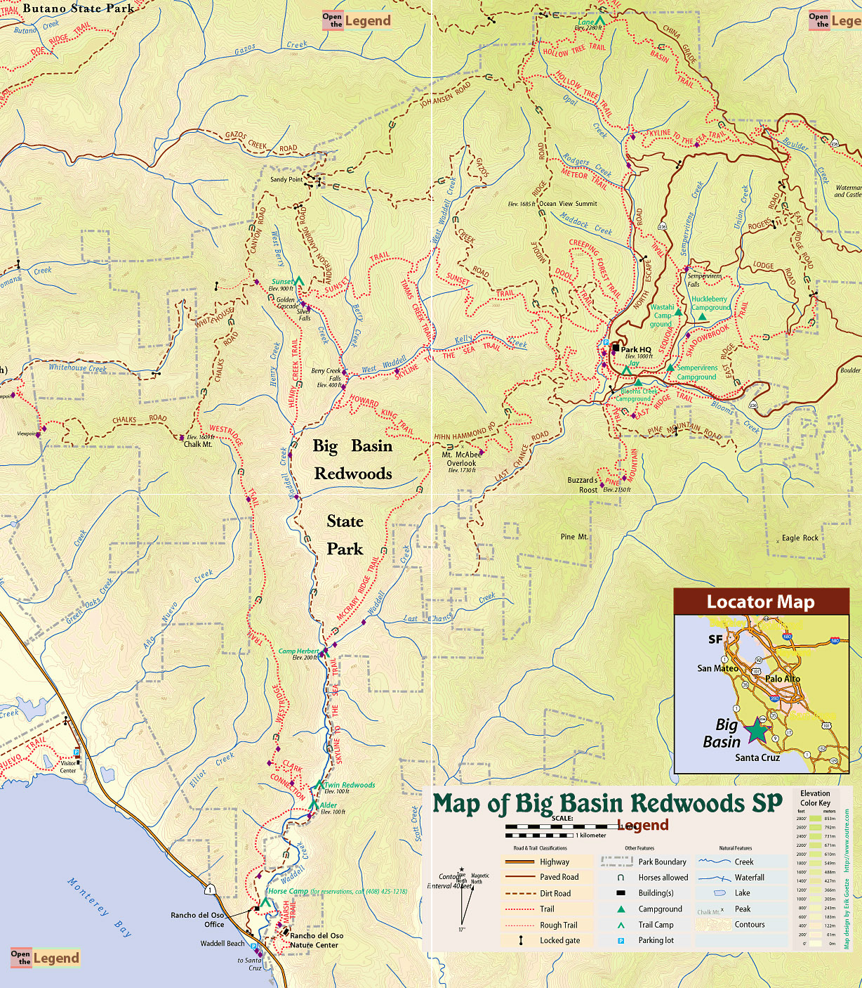
» RedwoodHikes Map: Excellent map showing trails near Chalk Mountain.
» Official Map: Large sized map without mileage information.
» Mappery.Com Trail Map: Good quality map showing various trails. Mileage of trail sections is missing. This is a JPEG image of the Virtual Parks trail map.
» Redwood Hikes Map: Bay Area Trail Map: Saratoga to Big Basin, First edition, 2010. This is an excellent map sold by Dave Baselt ($6.95 in Dec 2011). This map is useful for exploring many parks in this area. Highly recommended for avid hikers.
To Chalk Mountain (2.7 miles): From the dirt pullout along Whitehouse Canyon Road, follow Whitehouse Ridge Trail (1.2 miles) → left on Chalk Mountain Road (1.5 miles) to Chalk Mountain. The hike starts off with a steep climb along Whitehouse Ridge Trail (500 ft in 0.4 miles). The trail is gorgeous, shaded by tall redwood trees. Chalk Mountain Road is in the open, providing panoramic views of Santa Cruz mountains and the Pacific. These views are pretty awesome.
To Berry Creek Falls (5.1 miles): From Chalk Mountain, continue along Chalk Mountain Road (2.1 miles) to a gated entrance to Henry Creek Trail (2.0 miles) → left on Skyline to the Sea Trail (0.9 miles) → left on Berry Creek Falls Trail (0.1 miles) to a wooden platform which provides awesome views of Berry Creek Falls. This is a good point to take a lunch break. Henry Creek Trail descends rapidly and some sections are steep.
To Trailhead (8.4 miles): From Berry Creek Falls, continue north along Berry Creek Falls Trail (1.0 miles), looking for a sign on the left for a trail that leads to Sunset Camp. Follow this unnamed trail (0.1 miles) to Sunset Camp → right on Anderson Landing Road (1.1 miles) to a gate. Turn left on Whitehouse Canyon Road (1.5 miles) to a gated junction with Henry Creek Trail. Continue straight along the fire road, which is now called Chalk Mountain Road (2.1 miles) to a junction with a spur trail leading to Chalk Mountain. Instead of taking the spur, continue straight along Chalk Mountain Road (1.4 miles), looking for a junction with Whitehouse Ridge Trail. This junction had a large faded sign in Dec 2012 and it is possible to miss it. Turn right along Whitehouse Ridge Trail, which is a single track hiking trail descending down a forest (1.2 miles) back to the trailhead.
Notes:
- Waterfalls and cascades: Berry Creek Falls Trail is exceptionally beautiful, going all along a creek. In winters, after rains, the creek has plenty of water and Berry Creek Falls is awesome! A wooden platform has been erected for watching the falls. This is a good point for taking a lunch break. Further up north along the same trail, there are two other wterfalls and cascades. These are called Silver Falls and Golden Cascade. Both are magnificent. At one point, the trail goes over a series of steps with a handrail separating hikers from gushing water.
- Creek crossings along Henry Creek Trail: There are two creek crossings without any bridges. The first creek crossing is about six to eight feet wide. It requires a long jump. The second creek crossing is more than 30 feet wide and requires careful walking over rocks. Some of my friends discovered some fallen trees further downstream that allowed them to cross the creek.
- Creek crossings along Skyline to the Sea Trail: There are two creek crossings. Both have foot bridges, which are barely over the water level. It is possible that these foot bridges have been washed away. So be prepared for some adventure. In Dec 2012, we had to pull back one of the wooden bridges and re-adjust it so that we could cross over. The second foot bridge consisted of two long metallic beams, which required careful walking.
- Fire roads: The views all along various fire roads are pretty good. At a couple of spots along Chalk Mountain Road, one can see the Pacific Ocean as well.
- Flashlight: The idea time for this hike is after rains in winters, when creeks are full of water and waterfalls are brilliant. A sunny day in winters would make the hike really pleasant. Since days are shortest during the month of Dec - Jan, it is best to go prepared with flash lights, in case it gets dark.


Several creek crossings along the route. Two were without briges.


Wide fire road with expansive views of Santa Cruz Mountains and the Pacific Ocean.


