
An awesome shaded hike in Fall Creek with some steep sections for good cardio workout.
Location: Henry Cowell Redwoods State Park - Fall Creek Unit
» Redwood Hikes Map for Big Ben - Fall Creek hike: An excellent map by Dave Baselt showing Lost Empire Trail and Fall Creek Trails
» Redwood Hikes Map for Truck Trail - Fall Creek hike: An excellent map by Dave Baselt showing Truck Trail and Fall Creek Trails
» Official Trail Map: High quality trail map with countours and trails clearly shown.
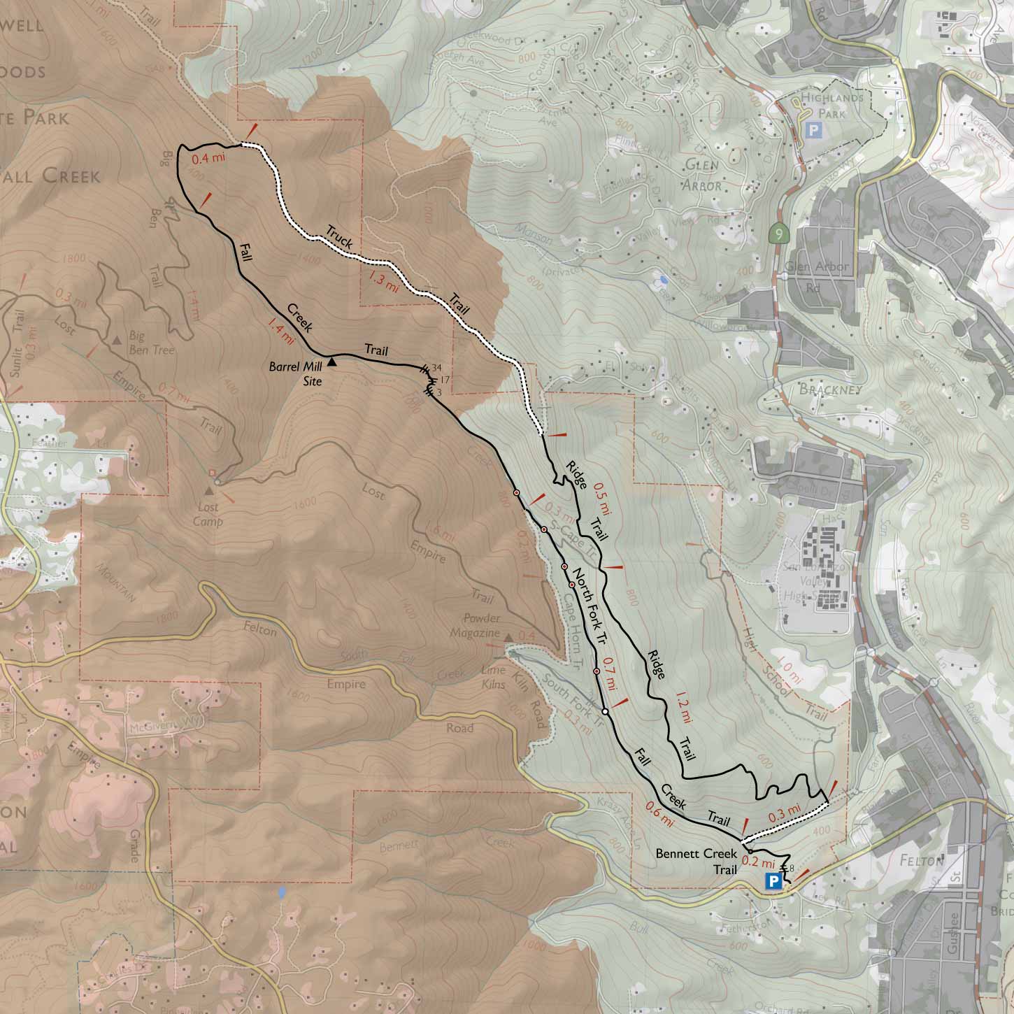
» Redwood Hikes Map: Annotated trail map of San Lorenzo Valley that shows many parks, not just Henry Cowell. This is an excellent map sold by Dave Baselt ($6.95 in Jan 2012).
» PeasePress Map: Trails of Santa Cruz: Excellent quality map showing various parks in the Santa Cruz area.
This hike is a combination of two hikes described at RedwoodHikes website: Big Ben and Fall Creek and Truck Trail and Fall Creek. Both of these hikes go through Fall Creek Trail. By combining the two routes, the hike stays from Fall Creek Trail.
Ascent to Big Ben (3.8 miles): Follow Bennett Creek Trail for 0.2 miles to a junction with Fall Creek Trail, which is all along Fall Creek. At the junction, choose the left fork towards Lime Kilns. After 0.6 miles along Fall Creek, turn left at a fork in the trail to walk 0.3 miles along South Fork Trail. Turn right along a fire road. In about 0.3 miles, a sign for Lost Empire Trail appears on the left. Follow Lost Empire Trail for 1.7 miles to reach Lost Camp, and another 0.7 miles to reach Big Ben, the highest point in this hike.
Return to trailhead (5.0 miles): From Big Ben, follow Big Ben Trail for 1.4 miles to reach Fall Creek. Continue along Big Ben Trail for 0.4 miles, then turn right on Truck Trail (1.3 miles) → Ridge Trail (1.4 miles) → right on High School Trail (0.1 miles) → right on unknown trail (0.2 miles) → left on Bennett Creek Trail (0.2 miles) to return to the parking lot.
Location: 1400 Felton Empire Rd Felton, CA 95018 . Parking area is visible in Google Maps if you zoom in sufficiently.
Directions: Along CA 17 south, exit Mount Hermon Rd in Scotts Valley. Drive 3.5 miles northwest along Mount Hermon Rd. Turn right on Graham Hill Road. In 0.1 miles, go through traffic light (Graham Hill becomes Felton Empire Rd at this intersection). Drive about 0.6 miles on Felton Empire Rd. Turn into a large parking lot marked by a sign for Henry Cowell Redwoods State Park.
Google Maps:
Parking Fees: None (last visited: Jan 2012)
Capacity: About 20 cars. At 8am, we were the first ones to park. When we finished the hike by 1:30pm, the parking lot was full.
Latitude: 37.049718 Longitude: -122.083155


 Full photo album — 7 January 2012
Full photo album — 7 January 2012