
An awesome hike in Big Basin going through varied terrain.
Location: Big Basin Redwoods State Park
 Large-sized Google Map
» Official Map: Large sized map without mileage information.
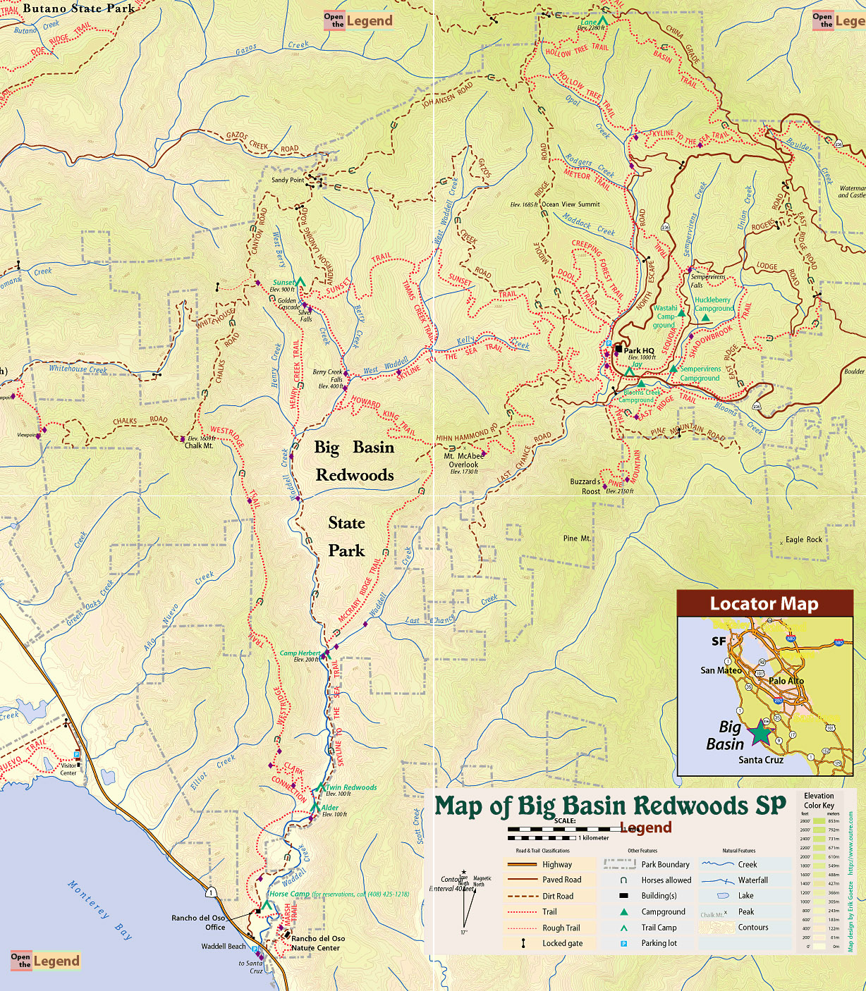
» Mappery.Com Trail Map: Good quality map showing various trails. Mileage of trail sections is missing. This is a JPEG image of the Virtual Parks trail map.
» Redwood Hikes Map: Bay Area Trail Map: Saratoga to Big Basin, First edition, 2010. This is an excellent map sold by Dave Baselt ($6.95 in Dec 2011). This map is useful for exploring many parks in this area. Highly recommended for avid hikers.
Sklyine to the Sea Trail (4.6 miles): From Park HQ, look for a large sign saying 'Redwood Trail'. Follow Redwood Trail. It quickly leads to Skyline to the Sea Trail. Turn right onto Skyline to the Sea Trail (2.0 miles) to reach a kiosk. This section of Skyline to the Sea is relatively flat, making it an easy stroll. Cross the bridge near the kiosk and turn left, following Skyline to the Sea Trail (0.5 miles) to reach an intersection with Hollow Tree Trail. Along this section, the trail initially meanders next to a creek, then starts climbing steadily. Continue following Skyline to the Sea Trail (1.6 miles) to reach a junction with Basin Trail. This section involves steady climbing and offers intermittent views of Santa Cruz mountains. Continue along Skyline to the Sea Trail (0.5 miles) to reach a paved road (Big Basin Way). Immediately after crossing the road, turn right onto East Ridge Trail.
East Ridge Trail (6.8 miles): From Big Basin Way, follow East Ridge Trail (0.7 miles) to an intersection with China Grade Road. Cross the road and continue along East Ridge Trail (0.3 miles) to reach a junction. Taking right at the junction leads up to a beautiful overlook point with a picnic table. This is a good point to stop for lunch. From the picnic table, retract your steps and turn right on East Ridge Trail (1.0 miles) to reach an intersection with Lodge Road. Cross the road and continue along East Ridge Trail (1.8 miles) to Hwy 236. This section of East Ridge Trail is really pretty: single track trail with great views of redwoods. Upon reaching Hwy 236, do not cross the highway. Instead, East Ridge Trail continues parallel to the highway (0.3 miles) to reach an intersection with Sempervirens Trail. If you are tired by this time, you may follow Sempervirens Trail and Sequoia Trail back to Park HQ. If you are feeling strong, cross Hwy 236 and continue along East Ridge Trail (1.9 miles) to reach an intersection with Pine Mountain Trail. This section of East Ridge climbs quickly, making it a decent workout. Continue along East Ridge Trail (0.1 miles) to reach a paved road. Turn left at the road, cross a bridge. Immediately after crossing the bridge, turn right on Skyline - Hihn Hammond Connector (0.4 miles) → right on Skyline to the Sea Trail (0.3 miles) to return to Park HQ.
Notes: The best sections of the hike were along Skyline to the Sea Trail (Park HQ to kiosk) and East Ridge Trail (from Lodge Road → Hwy 236 → Hinh Hammond Road). There are vista points along Skyline to the Sea Trail in the north (between Hollow Tree Trail and Basin Trail). The picnic table on East Ridge Trail, about 0.3 miles south of China Grade Road is an excellent spot to take a lunch break.
Location: 21600 Big Basin Way, Boulder Creek, CA 95006 . Parking area is not visible in Google Maps.
Google Maps:
Parking Fees: $10 per vehicle. (last visited: Jan 2012)
Capacity: Multiple parking lots. Dozens of cars may be parked inside the park.
Latitude: 37.171311 Longitude: -122.222203


