
A short but pleasant walk amid redwoods in Forest of Nisene Marks. Trout Gulch Trail is not shown in all maps and looked overgrown in March 2012.
Location: Forest of Nisene Marks State Park
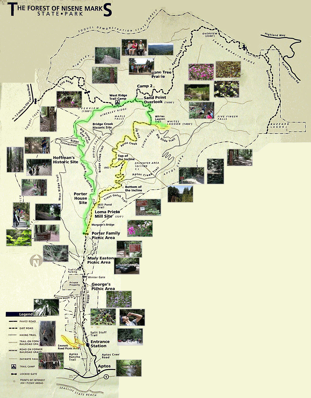
» Official Brochure: Official Trail Map with details of both Forest of Nisene Marks and Soquel Demonstration Forest. The area close to Entrance Station in Forest of Nisene Marks is shown enlarged. Trail lengths are missing in this map.
» PeasePress Map: Trails of Santa Cruz: Excellent quality map showing various parks in the Santa Cruz area.
Trail Map: Trout Gulch Trail is not shown all maps. It is probably unmaintained. Trail Map at Signite.Com shows its location.
Route: From George's Picnic Area, walk towards the bridge and continue walking along a wide fire road called Aptos Creek Fire Road (2.2 miles). Turn right on Trout Gulch Trail and follow it all the way until it ends (0.8 miles). Retrace your steps by the same trails, back to George's Picnic Area.
Porter Trail: This trail is a beautiful single-track hiking trail that connects Mary Easton Picnic Area to Porter Family Picnic Area. This trail provides an alternative to Aptos Creek Fire Road between these two points. There are two bridgeless creek crossings along this trail. After rainfall, the creeks have enough water to make your feet wet.
 Large-sized Google Map


Location: Along Aptos Creek Road, about one mile north of intersection of Aptos Creek Road and Soquel Drive, Aptos, CA. Near 'Steel Bridge' and 'Winter Gate' in the official map. . No street address. Parking area is not visible in Google Maps.
Directions: From Highway 17 going south, go along CA-1 South. After about six miles, take Exit 435 for State Park Drive towards Aptos. Soon after the exit, turn left onto State Park Drive. After 0.3 miles, take the second right onto Soquel Drive. In half a mile, you will reach the intersection of Soquel Drive and Aptos Creek Road in Aptos, CA. Turn left onto Aptos Creek Road and drive about a mile to reach the Park Entrance kiosk where you would have to pay entrance fees. Drive another mile to reach George's Picnic Area, which is near 'Steel Bridge' and 'Winter Gate' in the official map.
Google Maps:
Parking Fees: $8 per vehicle (last visited: March 2014)
Capacity: About 15 cars
Latitude: 36.997309 Longitude: -121.906507