
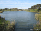
Bass Lake is off the same trail that leads to Alamere Falls. Swimming is allowed in the lake. Many people make a side trip to Bass Lake on their way to Alamere Falls.
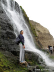
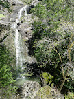
Alamere Falls in Point Reyes is one of the two waterfalls in CA that pour directly into the Pacific Ocean. The waterfall is 40 ft tall. The final descent to the beach requires a scramble. In 2012, there was a rope to make the descent safer. During low tide, one may walk half a mile to the south of the beach and several miles to the north to reach Wildcat Camp. The beach walk adds character to the hike.
|
9.5 miles
1000 ft |
Alamere Falls from Palomarin Trailhead |
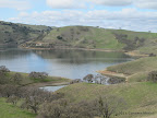
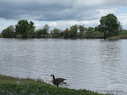
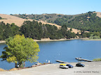
Del Valle Lake is a large serene lake in Livermore. There are hiking trails all along the eastern side of the lake.
|
9.3 miles
800 ft |
East Shore Trail in Del Valle |
|
9.0 miles
800 ft |
Lake Chabot Loop |

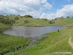
Henry Coe is a gigantic park with over 250 miles of hiking trails. Mississippi Lake is deep inside the park. For one weekend in an year, a road going into the deeper sections of Henry Coe is opened to visitors. On that weekend, Mississippi Lake is reachable by an 11-mile hike.
|
11.2 miles
1900 ft |
Mississippi Lake from Orestimba Corral |
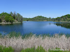
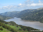
Kent Lake is the largest lake in Mt Tamalpais Watershed area. The hikes below provide lake access. The routes go along the lake for only a few hundred yards, unlike other lakes in the bay area which can be circumnavigated. The route to Kent Lake goes via Carson Falls, a seasonal waterfall that is best seen after rains in spring. Optionally, one may make the hike longer with a side trip to Pine Mountain for great valley views.
|
9.1 miles
1700 ft |
Carson Falls - Kent Lake - Pine Mountain - Route I |
|
6.7 miles
1500 ft |
Carson Falls - Kent Lake - Route I |
A medium sized lake in Stevens Creek County Park. Stevens Creek / Tony Look Trail meanders along the banks of the lake for about a mile. This lake cannot be circumnavigated because there are no hiking trails on the western side of the lake.
|
7.0 miles
1000 ft |
Tony Look - Coyote Ridge |

Pacheco State Park has several small sized lakes. From spring to early summer, hills are lush green, with wildflowers along some trails.
|
10.5 miles
1800 ft |
Three Lakes via Spikes Peak |
Crystal Springs Reservoir and San Andreas Lake are two long lakes in San Mateo with hiking trails along the eastern banks of the lake. Trails are paved and popular among hikers, joggers and cyclists.
|
12.0 miles
300 ft |
Sawyer Camp Trail |

Lafayette Reservoir in Lafayette is a popular lake with picnic areas and trails around the lake. There are two loops. The shorter loop is paved and stays next to the lake at all times. The longer loop is rugged with some exceptionally steep sections. It is also in the open, so avoid summers. Views from the longer loop are pretty good.
|
5.1 miles
900 ft |
Long Loop around Lafayette Reservoir |

|
2.9 miles
500 ft |
Short Loop around Lafayette Reservoir |

Don Castro Reservoir is a small lake in Hayward with picnic areas and a swimming lagoon adjacent to the lake. The lake can be circumnavigated by hiking trails. Some junctions are unmarked. For those seeking a longer route startingat Don Castro Lake or going via the lake, there is the Chabot Garin Trail in the eastern end of the lake.
|
2.1 miles
0 ft |
Don Castro Loop |

Loch Lomond is a large lake in Santa Cruz. Half of the eastern bank has a hiking trail adjoining the lake. This trail is almost always shaded and pretty awesome. Access to Loch Lomond is via twisty roads through residential areas.
|
5.0 miles
800 ft |
Loch Trail - Highlands Trail |

Shadow Cliffs Lake is a large lake in Pleasanton is quite popular with a large picnic area. Trails in the north and the south of the lake gain elevation and provide excellent views of the lake from various angles.
|
5.0 miles
100 ft |
Long Loop near Shadow Cliffs Lake |

|
2.7 miles
100 ft |
Short Loop near Shadow Cliffs Lake |
Contra Loma Lake in Antioch is a calm serene lake with a well developed picnic area in the south. A loop trail going all around the lake offers ever changing views of the lake. On the western side, there are trails going through hills. Even better views of the lake are available from these hills.
|
5.7 miles
600 ft |
Long Loop in Contra Loma Park |
Lake Merritt in Oakland has a paved path encircling the lake. It is surrounded by roads and buildings, so there is constant noise of city traffic everywhere. The three mile loop around Lake Merritt a good urban walk, available to local residents without having to drive afar.
|
3.3 miles
100 ft |
Lake Merritt Loop |

Lake Temescal in Oakland is a small sized lake with a well developed picnic area and a 'beach area' with plenty of sand. It can be circumavigated with a short one mile loop. The trail in the west of the lake has a wilderness feel to it.
|
1.1 miles
50 ft |
Lake Temescal Loop |

Lake Merced is a large lake in San Francisco that may be circumnavigated by walking along paved trails next to city roads. Traffic noise is quite prominent.
|
1.7 miles
50 ft |
North Lake Loop |
San Pablo Reservoir has hiking trails all along the western side. In the south, the trail is along a paved road and is quite far away from the banks of the lake. In the north, Whopper Trail goes very near the lake. The trails which go near the lake and are quite pleasant, were unmarked in September 2010.
|
12.5 miles
700 ft |
Orinda Connector to Kennedy Grove |
Coyote Lake is a very large lake in Gilroy. There is a network of trails all along the western side of the lake. However, lake access is possible only at the northern end of this trail network. Lake views are occasional even from atop the ridges in the west.
|
12.3 miles
1200 ft |
Mummy Mountain - Coyote Ridge - Calaveras - Valley Oak |
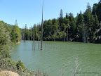
Alpine Lake is a large serene lake in Mt Tamalpais Watershed. The hike below is fairly secluded and provides access to one of the arms of Alpine Lake.
|
0.7 miles
100 ft |
Alpine Lake |

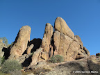
Bear Gulch Reservoir is a small sized lake near Bear Gulch Caves. The views of the lake surrounded by rocky hills are pretty good. The lake cannot be circumnavigated. Trails skirt around the lake in the east. Bear Gulch Reservoir could be a good destination for those doing a short hike to Bear Gulch Caves.
|
6.2 miles
1500 ft |
Bear Gulch Cave, High Peaks from Bear Gulch Day Use Area - Route I |
Lake Boronda is a small lake in Foothills Park with hiking trails in the south.
|
11.4 miles
2000 ft |
Los Trancos Trail - Long Loop |
