
Andrew Molera is 20 miles south of Carmel, CA, on Highway 1. Best visited in winters and spring, when it is green and spring flowers abound. The park offers great views of the Pacific, access to beaches and trails next to Big Sur River. There is a picnic area close to the entrance and 24 campsites next to Big Sur River, about half a mile away.
Best Months to Visit: Winters and spring, after rains. Trails are in the open, so avoid summers.
The foot-bridge over Big Sur River that provides access to various trails is seasonal. Call park authorities before making a visit
The Big Sur Trail Marathon is held annually at Andrew Molera State Park.
Hikes to the West of Hwy 101
The western section of Andrew Molera is where most people hike in Andrew Molera.
|
8.2 miles
1400 ft |
Ridge Trail - Panorama Trail - Bluffs Trail |

Hikes to the East of Hwy 101
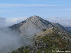
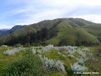
The eastern section of Andrew Molera has rugged trails, with some steep sections. All of these trails are mostly in the open, going through green rolling hills and occasionally providing expansive views of the Pacific.
|
11.2 miles
4300 ft |
Cabezo Prieto Ridge |

|
8.9 miles
3600 ft |
Post Summit |
|
13.1 miles
5000 ft |
Post Summit - Manuel Peak |
© Copyright 2008—2023, Gurmeet Manku.