Hikes in Butano State Park
1 Jan 2012

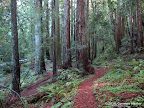
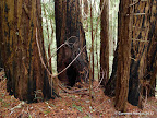
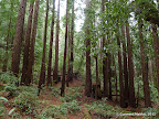
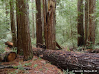
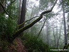
Butano State Park is one of my favorite parks with shaded trails. Little Butano Creek Trail is a lovely trail that meanders next to Little Butano Creek for about two miles. For longer hikes, there are single track trails like Jackson Flats Trail, Canyon Trail and Doe Ridge Trail, which are mostly shaded.

Best time to visit: In winters, after rains, Little Butano Creek is flowing with water and vegetation is lush green. Try to include the Little Butano Creek Trail in your route.

Short Hikes through Little Butano Creek Trail

Little Butano Creek Trail is a gorgeous trail in Butano State Park. It meanders next to Little Butano Creek, crossing it a few times. In winters, after rains, any hike that includes this trail is wonderful.

4.3 miles
500 ft
Little Butano Creek Trail - Route I
Awesome hike along Little Butano Creek Trail that meanders next to Little Butano Creek for about two miles.

4.6 miles
700 ft
Little Butano Creek - Route II
A varation of Route I.

5.1 miles
900 ft
Little Butano Creek and Ano Nuevo Trails - Route I
This route descends via the Ano Nuevo Trail, which is pretty steep. It loses 800 ft in about 0.8 miles.

5.5 miles
1000 ft
Little Butano Creek and Ano Nuevo Trails - Route II
A varation on Route I going through Ano Nuevo Trail.

8.5 miles
1700 ft
Little Butano Creek - Ano Nuevo - Candleabra - Route I
Candleabra Trail is a shaded trail that loses 900 ft in 1.7 miles, from Olmo Fire Road to Gazos Creek Road. The back and forth along Candleabra Trail addes 3.4 miles to the hike.

8.2 miles
1900 ft
Little Butano Creek - Ano Nuevo - Candleabra - Route II
A variation of Route I that goes through Candleabra Trail.

Long Loops through Single Track Hiking Trails

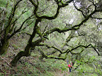
Jackson Flats Trail, Canyon Trail and Doe Ridge Trail are single track hiking trails taking you deeper into the park. Here are some long routes that include these magnificent trails.

10.5 miles
1500 ft
Long Loop in Butano - I
Jackson Flats → Canyon Trail → Indian Trail → Doe Ridge Trail → Little Butano Creek Trail → Six Bridges Trail.

9.1 miles
1400 ft
Long Loop in Butano - II
Jackson Flats → Canyon Trail → Indian Trail → Doe Ridge Trail → Ben Ries Campground → Six Bridges Trail.

9.1 miles
1500 ft
Long Loop in Butano - III
Jackson Flats → Canyon Trail → Indian Trail → Doe Ridge Trail → Goat Hill Trail → Ano Nuevo Trail. Note that Ano Nuevo is pretty steep, descending 800 ft in about 0.8 miles.

12.5 miles
2300 ft
Long Loop in Butano - IV
A variation of Route III, with a side trip to Candleabra Trail. This adds 3.4 miles and 900 ft to the total elevation gain.

12.9 miles
2000 ft
Ray Linder Memorial - Route I
Ray Linder Memorial Trail lies in the far west corner of Butano State Park. The return trip is via the gorgeous Little Butano Creek Trail.

11.4 miles
2000 ft
Ray Linder Memorial - Route II
A varation of Route I with return trip via Ben Ries Campground.

11.5 miles
2100 ft
Ray Linder Memorial - Route III
A varation of Route I with return trip via the steep Ano Nuevo Trail which loses 800 ft in 0.8 miles.

13.9 miles
2900 ft
Ray Linder Memorial - Route IV
A variation of Route III with a side trip to Candleabra Trail. This adds 3.4 miles and 900 ft to the total elevation gain.

18.0 miles
3300 ft
Grand Loop in Butano
A very long route that goes through almost all of the single track trails in Butano, without going through anys trail section twice.

Long Loops through Butano Fire Road

Butano Fire Road runs from west to east, along the northern boundary of Butano State Park. Here are some routes that include the fire road. Most hikers avoid fire roads and prefer single track hiking trails. Those who would like to explore northern section of the park would find these routes interesting.

11.4 miles
1900 ft
Butano Trail Camp - Route I
Ascent to Butano Trail Camp via Butano Fire Road. Return via Canyon Trail and Jackson Flats Trail.

11.9 miles
1700 ft
Butano Trail Camp - Route II
Ascent to Butano Trail Camp via Butano Fire Road. Return via Olmo Fire Road, Doe Ridge Trail and Little Butano Creek Trail.

10.5 miles
1700 ft
Butano Trail Camp - Route III
Ascent to Butano Trail Camp via Butano Fire Road. Return via Olmo Fire Road, Doe Ridge Trail and Ben Ries Campground.

10.5 miles
2000 ft
Butano Trail Camp - Route IV
Ascent to Butano Trail Camp via Butano Fire Road. Return via Olmo Fire Road, Doe Ridge Trail and Ano Nuevo Trail, which is quite steep (it loses 800 ft in 0.8 miles).

13.9 miles
2800 ft
Butano Trail Camp - Route V
An extension of Route IV, with a side trip to Candleabra Trail, a shaded trail that loses 900 ft in 1.7 miles, from Olmo Fire Road to Gazos Creek Road. The back and forth along Candleabra Trail addes 3.4 miles to the hike.

13.3 miles
2300 ft
Ray Linder Memorial via Butano Fire Road - Route I
Ascent to Ray Linder Memorial via Butano Fire Road. Return via Canyon Trail and Jackson Flats Trail.

12.9 miles
1900 ft
Ray Linder Memorial via Butano Fire Road - Route II
Ascent to Ray Linder Memorial via Butano Fire Road. Return via Olmo Fire Road, Doe Ridge Trail and Little Butano Creek Trail.

11.5 miles
1700 ft
Ray Linder Memorial via Butano Fire Road - Route III
Ascent to Ray Linder Memorial via Butano Fire Road. Return via Olmo Fire Road, Doe Ridge Trail and Ben Ries Campground.

11.5 miles
2300 ft
Ray Linder Memorial via Butano Fire Road - Route IV
Ascent to Ray Linder Memorial via Butano Fire Road. Return via Olmo Fire Road, Doe Ridge Trail and Ano Nuevo Trail, which is quite steep (it loses 800 ft in 0.8 miles).

14.9 miles
3100 ft
Ray Linder Memorial via Butano Fire Road - Route V
An extension of Route IV, with a side trip to Candleabra Trail, a shaded trail that loses 900 ft in 1.7 miles, from Olmo Fire Road to Gazos Creek Road. The back and forth along Candleabra Trail addes 3.4 miles to the hike.

© Copyright 2008—2023, Gurmeet Manku.