Hikes in Las Trampas Regional Wilderness
1 Jan 2012
Las Trampas Regional Preserve is a large-sized (5342 acres) park with an extensive trail system that would take you into rugged and remote areas with few other hikers in sight. The park adjoins the Upper San Leandro Reservoir, which falls under EBMUD. Hiking in EBMUD land requires a permit which may be purchased online. Most trails provide grand panoramic vistas of valleys and cities nearby. You may even see San Francisco from some points. On foggy days in winters, you shall be enchanted by eerie views of trees and trails around you. The park reminds me of Sunol Regional Wilderness.

Best Months to Visit: Winters and spring are best. Allow a few days after rains for water to dry up, otherwise trails could be muddy.

Hikes to Rocky Ridge with One Hill Climb

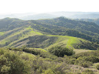
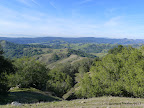
Rocky Ridge lies in the western section of Las Trampas, about 900 ft climb from the Staging Area. Panoramic, hilly views from Rocky Ridge are pretty awesome.

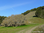
Three trails lead up to Rocky Ridge: Rocky Ridge View Trail, Cuesta Trail and Elderberry Trail. The steepest route is along Rocky Ridge View Trail. It climbs about 900 ft in one mile, making it one of the steepest trails in the bay area. The other two trails are gently sloping.

3.6 miles
1000 ft
Rocky Ridge View - Cuesta
Ascent via Rocky Ridge View Trail. Descent via Cuesta Trail.

4.7 miles
1000 ft
Cuesta - Elderberry
Ascent via Cuesta Trail. Descent via Elderberry Trail.

4.7 miles
1000 ft
Rocky Ridge View - Elderberry
Ascent via Rocky Ridge View Trail. Descent via Elderberry Trail.

5.1 miles
1200 ft
Rocky Ridge - Cuesta with Warmup Loop
Ascent via Rocky Ridge View Trail. Descent via Cuesta Trail. A warmup loop along Bollinger Creek Loop Trail (1.5 miles, 200 ft) prepares us for the steep ascent along Rocky Ridge View Trail.

Hikes to Rocky Ridge with Two Hill Climbs

The routes below have two steep hill climbs. They combine the routes listed above (with one hill climb) with a side trip to Sycamore Trail (1000 ft descent in 1.3 miles) followed by Devil's Hole Trail (900 ft climb in 1.3 miles). Some sections along these two trails are fairly steep.

6.3 miles
2000 ft
Rocky Ridge View - Cuesta
Ascent via Rocky Ridge View Trail. Descent via Cuesta Trail. Side Trip to Sycamore Trail and Devil's Hole Trail.

7.3 miles
2200 ft
Cuesta - Elderberry
Ascent via Cuesta Trail. Descent via Elderberry Trail. Side Trip to Sycamore Trail and Devil's Hole Trail.

6.6 miles
1900 ft
Rocky Ridge View - Elderberry
Ascent via Rocky Ridge View Trail. Descent via Elderberry Trail. Side Trip to Sycamore Trail and Devil's Hole Trail.

7.8 miles
2200 ft
Rocky Ridge View - Cuesta with Warmup
Ascent via Rocky Ridge View Trail. Descent via Cuesta Trail. Side Trip to Sycamore Trail and Devil's Hole Trail. A warmup loop along Bollinger Creek Loop Trail (1.5 miles, 200 ft) prepares us for the steep ascent along Rocky Ridge View Trail.

Hikes requiring EBMUD Permit
7.1 miles
2000 ft
Rocky Ridge Loop
A great hike over remote rolling hills with panoramic valley views. Best done in spring when hills are green.

12.3 miles
3600 ft
Rocky Ridge Loop - Ramage Peak Trail
A great hike over remote rolling hills with panoramic valley views. Best done in spring when hills are green.

© Copyright 2008—2023, Gurmeet Manku.