
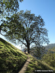
Maguire Peaks lie in the northern section of the park. Two short routes start from two different points along Welch Creek Road. Parking requires permit, which can be obtained from the visitor center, which lies a few miles south (see trail map).
|
5.2 miles
1000 ft |
Maguire Peaks Loop I |

|
6.4 miles
1400 ft |
Maguire Peaks Loop II |
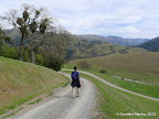
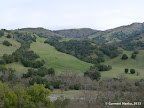
Flag Hill Trail is a fairly steep trail that quickly leads up to Flag Hill. Views from Flag Hill are quite spectacular: green rolling hills in spring are a joy to absorb. The first 1.1 miles climbs up about 1000 ft, making it a good cardio workout. From Flag Hill, there are many options to complete a loop. All options are equally good for valley views.
|
4.4 miles
1100 ft |
Flag Hill and Indian Joe Creek |

|
6.0 miles
1700 ft |
Flag Hill, Vista Grande and Indian Joe Creek |
|
8.0 miles
2100 ft |
Flag Hill, Vista Grande, Little Yosemite |

Routes without Flag Hill have gentler slopes. Two options are to climb up the hills in the north via Indian Joe Creek Trail, or explore the area in the south-east: Little Yosemite Area.
|
5.1 miles
1400 ft |
Indian Joe Creek, McCorkle Trail |

The loops below are fairly challenging, as they go through steep hills. All of the routes are equally gorgeous in spring, when hills are lush green.
|
11.1 miles
2800 ft |
Flag Hill, Maguire Peaks |

|
12.4 miles
3500 ft |
Long Loop I in Sunol |

Mission Peak lies to the west of Sunol Wilderness, reachable by a 10-mile route. This hike entails walking along the Ohlone Wilderness Trail, which requires a permit from the entrance kiosk.
|
10.4 miles
2100 ft |
Short Route |
|
16.4 miles
4200 ft |
Long Route |

|
8.6 miles
2100 ft |
From Sunol to Ohlone College |
|
8.1 miles
2100 ft |
Sunol — Stanford Ave - I |

|
8.6 miles
2100 ft |
Sunol — Stanford Ave - II |

The 28-mile Ohlone Regional Wilderness Trail passes through Sunol. In the east, this trail leads to Rose Peak, which offers 360-degree views for hundreds of square miles.
|
19.6 miles
4200 ft |
Rose Peak from Sunol Wilderness |
