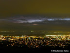
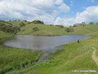
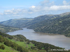
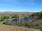
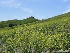
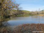
Rose Peak is located right in the middle of the 20-mile Ohlone Wilderness Trail between Del Valle Regional Park in Livermore and Sunol Regional Wilderness in Sunol. So one may either hike from Del Valle, or from Sunol. Both hikes are 20 miles round trip. 360-degree views from Rose Peak are pretty awesome. Trails are rugged with some steep sections. The best season is spring when hills are lush green. The hike may also be done in early winters, before rains. Most of the route is in the open, so summer hikes become overly strenuous.
Some groups do an end to end hike as follows: they divide themselves into two sub-groups, start from both trailheads and meet at Rose Peak to swap their car keys.
|
20.2 miles
4500 ft |
Rose Peak from Del Valle Lake |

|
19.6 miles
4200 ft |
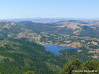
Rose Peak from Sunol Wilderness |

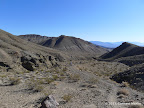
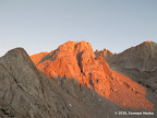
Post Summit in Big Sur is along a lightly traversed trail along Cabezo Prieto Ridge. There are two approaches: from Andrew Molera State Park and from Pfeiffer Big Sur State Park.
One may do an end to end hike all along the Cabezo Prieto Ridge through Post Peak. For such an end-to-en hike, there is a challenge: the section between Post Peak and Mount Manuel was unmaintained in February 2012, going through thick brushes at some points. So either go with a group that knows the trail well, or be ready for some adventure.
|
8.9 miles
3600 ft |
Post Summit |

|
13.1 miles
5000 ft |
Post Summit - Manuel Peak |
|
11.2 miles
4300 ft |
Cabezo Prieto Ridge |
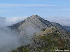
Mount Manuel in Big Sur is along a well maintained trail in Pfeiffer Big Sur Park. One may also approach Mount Manuel from Andrew Molera via the Cabezo Prieto Ridge Trail. Note that the section between Post Peak and Mount Manuel was unmaintained in February 2012, going through thick brushes at some points. So either go with a group that knows the trail well, or be ready for some adventure.
|
9.5 miles
3500 ft |
Manuel Peak |

|
13.4 miles
5000 ft |
Manuel Peak - Post Summit |

|
11.2 miles
4300 ft |
Cabezo Prieto Ridge |
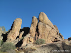
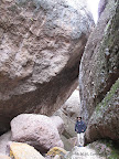
Pinnacles National Monument in Hollister has a section called High Peaks which offers majestic views of valleys below. Several different routes may be formed in Pinnacles that go through High Peaks.
|
6.2 miles
1500 ft |
Bear Gulch Cave, High Peaks from Bear Gulch Day Use Area - Route I |
|
12.7 miles
2600 ft |
Balconies Cave, High Peaks & Bear Gulch Cave from Bear Gulch Day Use Area - Route I |
|
13.0 miles
3900 ft |
Eagle Peak - Mount Diablo - Mitchell Canyon |

|
7.8 miles
2300 ft |
Mitchell Canyon - Eagle Peak |
|
13.0 miles
3900 ft |
Eagle Peak - Mount Diablo - Mitchell Canyon |

|
9.9 miles
3000 ft |
Mt Olympia from Regency Drive |
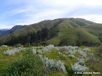
Mission Peak is the most popular destination among fitness enthusiasts. The hike climbs 2100 ft in three miles. Views all along are pretty good. The hike is best done in spring when lush green grass carpets the valleys. In summers, many people start before dawn for awesome morning views of east bay as the sun rises in the east.
|
6.1 miles
2100 ft |
Mission Peak from Stanford Ave - Route I |

|
6.1 miles
2100 ft |
Full Moon Hike to Mission Peak |
Mount Burdell is in Novato. The popular route to the peak is from San Andreas Drive, with 1100 ft climb and 5.5 miles round trip. Some sections of the trail are steep. An alternative longer but gentler route is from Olompali State Historic Park.
|
5.5 miles
1100 ft |
Mount Burdell from San Andreas Drive |

|
10.5 miles
1500 ft |
Mount Burdell from Olompali Park |

Montara Mountain entails a steep climb along a combination of fire roads and unmaintained paved roads. Great fitness hikes in Pacifica.
|
20.6 miles
4400 ft |
Grand Loop in McNee Ranch and San Pedro Valley |

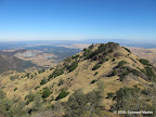
The hike to Doud Peak goes through a variety of different terrains: cool redwoods and open ridges. The hike is pretty strenuous. It is harder than Mission Peak (2100 ft, 6.0 miles). Even though the elevation gain and mileage is similar for the two hikes, Doud Peak is more challenging because elevation gain is not uniform — many sections are steeper.
|
6.2 miles
2200 ft |
Doud Peak |

On a clear day, East Peak in Mt Tamalpais offers incredible views of San Pablo Bay and San Francisco Bay. Mt Tamalpais is criss-crossed by myriad trails, so there are multiple hikes to East Peak from different trailheads.
|
10.1 miles
2000 ft |
East Peak from Pantoll Ranger Station — Route I |

|
5.0 miles
1600 ft |
East Peak from Fern Canyon Road — Route I |

|
7.0 miles
1800 ft |
East Peak from Fern Canyon Road — Route II |
Many routes lead to Black Mountain in Monte Bello. These routes start at various parks adjoining Monte Bello. The shortest hike is from Monte Bello trailhead.
|
7.0 miles
1500 ft |
Black Mountain from Page Mill Road - Route III |

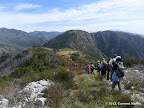
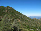
An awesome hike with great valley views in Ed Levin County Park. Slightly easier than the hike to Mission Peak. It is possible to form longer loops by going all the way to Mission Peak, which is connected by trails with Ed Levin County Park. Is is best to visit Monument Peak in spring when hills are lush green.
|
9.2 miles
2200 ft |
Monument Peak from Ed Levin |

Mt St Helena is the highest summit in Napa Valley. Great views of various towns occupying the land surrounding the peak. The initial section of the hike is through a forest. After a mile, the route is along a wide fire road that slowly makes its way to the top.
|
9.8 miles
2100 ft |
Mt St Helena |

Pine Mountain in Mt Tamalpais Watershed area offers panoramic views of green valleys nearby and San Francisco Bay in the distance. The hike to Pine Mountain is along fire roads, in the open. A hike to Pine Mountain may be combined with hikes to nearby Carson Falls, a cascade of seasonal waterfalls with plenty of water after rains. For a longer trip, one may additionally visit Kent Lake. Pine Mountain may also be approached from the nearby Cascade Canyon Open Space Preserve via the unmarked but well maintained Happersberger Trail.
|
6.2 miles
1500 ft |
Carson Falls - Pine Mountain - Route I |

|
9.1 miles
1700 ft |
Carson Falls - Kent Lake - Pine Mountain - Route I |
|
8.0 miles
1800 ft |
Cascade Falls - Pine Mountain |
Wildcat Peak in Tilden Regional Park is a popular destination for hikes starting from Tilden or the adjoining Wildcat Canyon Regional Park. A series of benches awaits you at Wildcat Peak.
|
12.5 miles
1500 ft |
Wildcat Peak from Alvarado Area |

Spikes Peak in Pacheco goes over green rolling hills. The peak does not stand out prominently from its surroundings. Many different loops may be formed that go through Spikes Peak. The hike is best done in spring, after rains, for lush green hills and wildflowers.
|
10.5 miles
1800 ft |
Three Lakes via Spikes Peak |
Fremont Older in Saratoga has several hills that offer panoramic views: Hunter's Point, Maisie's Peak and Nob Hill.
|
6.6 miles
1700 ft |
Hunter's Point - Maisie's Peak - Nob Hill |

Mummy Mountain is a hill in Coyote Lake - Harvey Bear Ranch County Park in Gilroy. As of March 2011, it was not marked in the online trail map. However, it was shown in the park brochure with trail map that was available at the park entrance. The trail is parallel to Coyote Ridge Trail and Mendoza Trail, going through the point marked with a cross at elevation 1374'.
|
12.3 miles
1200 ft |
Mummy Mountain - Coyote Ridge - Calaveras - Valley Oak |
Buzzard's Roost is a vantage point in Big Basin, reachable by a short but steep hike.
|
4.8 miles
1400 ft |
Buzzard's Roost |

Coyote Peak in Santa Teresa County Park is a hill that offers awesome views of San Jose residential areas and green rolling hills adjoining the park.
|
5.6 miles
1200 ft |
Short Loop through Coyote Peak |
Hiddenbrooke Summit is reachable by a short hike from Bennington Drive through a combination of fire roads and single track trails. The views of Hiddenbrooke vally homes along the trail are pretty awesome.
|
3.2 miles
800 ft |
Sulphur Springs Mountain from Bennington Drive |
Tolman Peak in Dry Creek Pioneer Regional Park is a hill with great views of east bay residential areas and San Francisco Bay.
|
9.8 miles
1800 ft |
Tolman Peak - Jordan Lake |
Mount Ellen is a hill along a ridge trail in San Mateo Memorial Park that is reachable by a short hike from the Park entrance.
|
3.3 miles
800 ft |
Mount Ellen |

Mt Whitney is the tallest peak in continental USA
|
20.8 miles
6400 ft |
Mt Whitney Day Hike |
Cloud's Rest offers gorgeous views of the rocky Yosemite Valley. The views are superior to those found at Half Dome. There are two approaches to Clouds Rest: from Happy Isles and from Tenaya Lake.
|
20.1 miles
6000 ft |
Cloud's Rest from Happy Isles |

|
9.5 miles
4000 ft |
Corkscrew Peak |