
A pleasant walk from Montara Beach to Gray Whale Cove Beach with excellent views of the Pacific. The number of distinct wildflowers along this trail is probably the highest among bay area trais.
Location: Montara State Beach — Gray Whale Cove Beach
 Large-sized Google Map
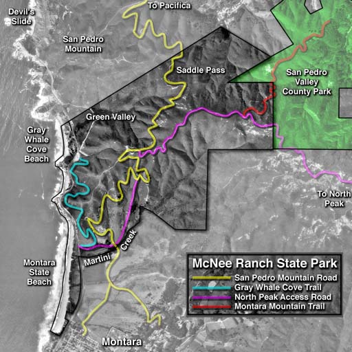
» Official Trail Map: Good map showing various trails. Mileage information is missing.
Trailhead: Southern entrance to Montara State Beach. If you start at the northern entrance, the hike gets shortened by a mile.
Route: From Montara State Beach to Gray Whale Cove Beach:
- (0.6 miles) Walk along Montara Beach.
- (0.1 miles) Exit the beach where Martini Creek meets the beach (study the trail map to find the location). A staircase leads you up into the northern entrance of Montara State Beach which has parking for about 12 cars.
- (0.1 miles) Walk north along Highway 1. Then cross Highway 1 carefully (there is no crosswalk). You will see a sign for "Montara State Beach | McNee Ranch", with street parking for 3 to 4 cars next to the sign. Google Map for location of this entrance.
- (1.2 miles) Follow signs for Gray Whale Cove Trail. This trail meanders next to Highway 1 with great views of the Pacific and beaches along the way. The trail finally descends down into the parking lot for Gray Whale Cove Beach. The parking lot lies to the east of Highway 1.
- (0.1 miles) Cross Highway 1 carefully (there is no crosswalk). The entrance to Gray Whale Cove Beach is not immediately visible. Walk a short distance north along Highway 1 until you reach a wide gate and a paved road going down to the beach.
- (0.3 miles) Descend down to Gray Whale Cove Beach. Walk to the southern end of the beach.
Notes:
- Yelp Reviews for Gray Whale Cove State Beach. A section of this beach is clothing optional.
- Gray Whale Cove Trail has an amazing variety of wild flowers in spring. In May 2011, I photographed more than 30 different species.
- At the southern end of Gray Whale Cove Beach, there was a small rock which we climbed amid splashing waves.
Location: 2nd street & Highway 1, Montara, CA 94037 . Parking area is visible in Google Maps if you zoom in sufficiently.
Directions: From CA-92 West, turn right onto Main Street and drive for 0.3 miles. Turn right onto CA-1 North adn drive for 7.4 miles. The parking lot for the southern entrance into Montara State Beach is to the south of a restaurant called La Constanera.
If parking is tight here, you may park at the northern entrance for Montara State Beach. See Google Map. The northern entrance is 0.5 miles to the north, along CA-1.
Google Maps:
Parking Fees: None (last visited: May 2011)
Capacity: Parking is tight. About ten cars may be parked here.
Latitude: 37.545439 Longitude: -122.514121


