
A beautiful loop around a Buddhist retreat center. About a third of the route is next to a creek, amid cool redwoods.
Location: Land of Medicine Buddha
 Large-sized Google Map
» Photo of Trail Map for Land of Medicine Buddha (from Feb 2012): Decent map showing various trails. Not to scale.
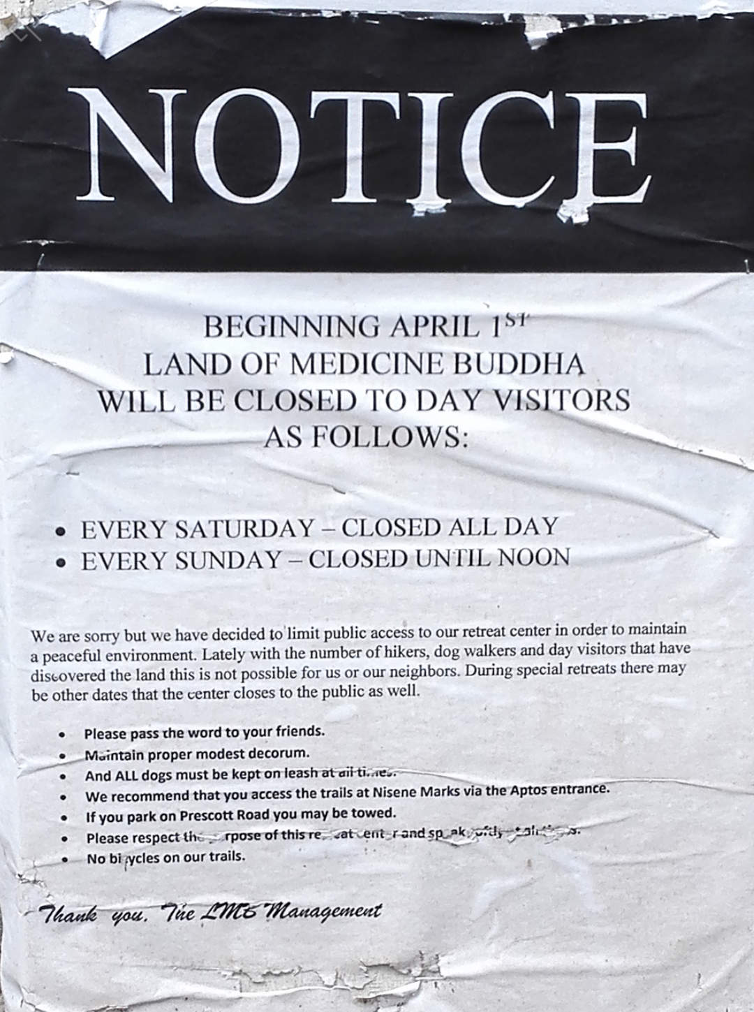
Closed on weekends: In Feb 2016, Land of Medicine Buddha posted a notice that from 1 April 2016 onwards, public access to Land of Medicine Buddha would be limited to weekdays and Sundays after noon. No public access on Saturdays. See the notice.
Since we got lost trying to find the trailhead and because all intersections are unmarked, the following notes may be helpful:
- We had to drive about half a mile further along Prescott Road, after our Garmin GPS said that we had reached 5800 Prescott Road, Soquel, CA to enter Land of Medicine Buddha.
- Printed maps are available inside the visitor center / bookshop. If that's closed, printed maps are also available in a small box next to the road (close to the prayer wheel across the visitor center) -- look for a sign saying 'Maps'. Photo of Trail Map from Feb 2012 (not to scale).
- We did the 6-mile loop clockwise. Finding the trail head was challenging (we got lost): The best approach is to start walking back along the road (drawn in thick black on the map) until you see a school on the right. Continue walking along the paved road until you see a very wide trail on the right, going parallel to a creek (Bates Creek). You would have to make a sharp right turn, more like a U-turn in the clockwise direction, to hop onto this trail. If you miss the sharp right / U-turn and reach the wooden bridge over which you drove your car to enter Land of Medicine Buddha, you have gone too far.
- The trail map shows a trail via 'playground' / school area, connecting the paved road with the 6-mile loop trail. We tried following this trail but got lost in the school area -- there were many unmarked trails in that area which are not shown on the map. So don't go towards the school / playground area.
- In approximately 0.3 or 0.4 miles, you can access Bates Creek by going down a hundred yards or so to your left -- it's worthwhile to check this out -- the sound of flowing water is soothing. When you come up to the main trail, within a short distance, you reach an unmarked intersection. Go left and stay next to the creek (see map -- the trail meanders next to the creek for a long time).
- There is a 'landslide' marked on the map -- this is a short section that's slippery after rains. So proceed slowly with caution -- all of us managed to negotiate this section, including a one-year old carried by her dad. No other section along the route was muddy / slippery.
- At 1.4 miles, the trail will cross Bates Creek. At the crossing, you can see a large fallen tree that's right above the creek.
- At 2.7 miles, there is an unmarked intersection with 'Western Ridge Trail' leading to Forest of Nisene Marks. This sign marks this intersection (it says "MTB's please respect the trail and slow down for hikers"). Turn right to continue the 6-mile loop within Land of Medicine Buddha.
- At 3.6 miles, we reached an unnamed intersection -- we stayed right. This is most likely the intersection soon after "Dried Brush / Loops" marked on the map.. but we didnt see any dried brush / loops along the trail.
- At 4.3 miles, we reached an intersection marked by "Prayer Flags" — these lie at the intersection of Logging Trail Loop towards Enchanted Forest and an unnamed trail leading back to parking lots. We turned left to go through the Enchanted Forest. If you turn right, you'll reach the parking lot faster, shortening the trip by about half a mile.
- At 5.1 miles, we reached a bifurcation (this is marked by "You Are Here" sign in this photo — the map seems older than the latest map). This spot lies between Verses 4 and 5 of the Eight Verses Pilgrimage Trail. You may turn either right or left. We turned right.
- At 5.5 miles, we reached the end of Eight Verses Pilgrimage Trail. It turned out that the Eight Verses Pilgrimage Trail is actually a short 0.75 mile loop close to the monastery / temples — it is not the long "7-mile loop" as I had originally thought by reading web descriptions.
- At 5.7 miles, we reached our cars.
Apart from the hike, you may wish to walk along the paved road and check out myriad murals, prayer wheels, temples, etc.
Location: Land of Medicine Buddha, 5800 Prescott Road, Soquel, CA 95073 . Parking area is not visible in Google Maps.
Google Maps:
Parking Fees: None (last visited: Feb 2012)
Capacity: About 20 to 30 cars may be parked inside the monastery.
Latitude: 37.011154 Longitude: -121.934555


There are eight verses at regular intervals along the Eight Verses Pilgrimage Trail.


