
Awesome hike through varied terrain in Butano, including redwoods, creeks and ridges.
Location: Butano State Park
Location: 1500 Cloverdale Road, Pescadero, CA 94060 . Parking area is not visible in Google Maps.
Google Maps:
Parking Fees: $10 per vehicle (last visited: Nov 2010)
Capacity: About a dozen cars.
Latitude: 37.201783 Longitude: -122.339287
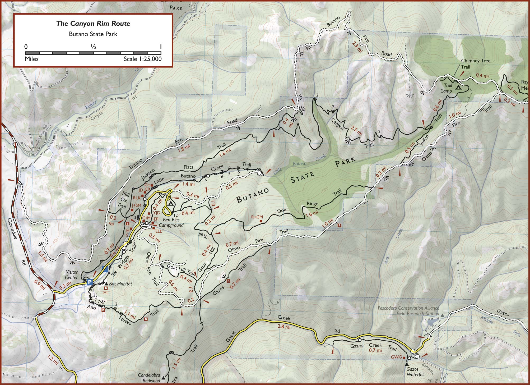
» Official Trail Map: Acceptable quality map but does not have mileage information of diferent trail sections.
» Redwood Hikes Map for Butano: An awesome map by Dave Baselt. Thanks, Dave! This map also shows the 1.7 mile long Candleabra Trail, which is missing in the official trail map.
» Redwood Hikes Map: Bay Area Trail Map: Saratoga to Big Basin, First edition, 2010. This is an excellent map sold by Dave Baselt ($6.95 in Dec 2011). This map is useful for exploring many parks in this area. Highly recommended for avid hikers.
To Ray Linder Memorial Trail (6.5 miles): From the parking lot behind entrance kiosk, follow Jackson Flats Trail (0.8 miles) → left on Mill Ox Trail (0.2 miles) → right on Butano Fire Road (1.8 miles) to reach an intersection with Jackson Flats Trail. Continue along Butano Fire Road (2.5 miles) to reach Trail Camp. Continue along Butano Fire Road (0.4 miles) to reach an intersection with Olmo Fire Road. Continue along Butano Fire Road. Within a few steps, turn left onto Ray Linder Memorial Trail (0.6 miles), a trail which loops back to Butano Fire Road. Turn right on Butano Fire Road (0.2 miles) to return to the intersection with Olmo Fire Road.
To Entrance Kiosk (6.8 miles): Turn left on Olmo Fire Road (1.0 miles) → right on Indian Trail (0.5 miles) → left on Canyon Trail (2.7 miles) → left on Jackson Flats Trail (1.6 miles) → left on Mill Ox Trail (0.3 miles) to reach a paved road. Cross over and follow Olmo Fire Road, then turn right onto Six Bridges Trail (0.7 miles) to return to the entrance kiosk.
Notes: In Dec 2012, the western section of Jackson Flats Trail presented many obstacles. A storm had felled many trees. All other trails were in excellent condition. Jackson Flats Trail goes through a forest, completely shaded. Canyon Trail goes through a combination of forest cover and valley views.
Forested trail through redwoods.


 Full photo album — 15 December 2012
Through thick forests, creek crossings and sometimes offers panoramic valley views.


Full photo album — 15 December 2012
A short loop through forest

Full photo album — 15 December 2012
Gorgeous valley views along the eastern section of the fire road, between Butano Fire Road and Indian Trail. The western section is wooded.


Full photo album — 15 December 2012
Full photo album — 15 December 2012